- 1,630-hectare property located in an underexplored part of the same geological terrane as Newmont’s Coffee Gold project and White Gold’s projects
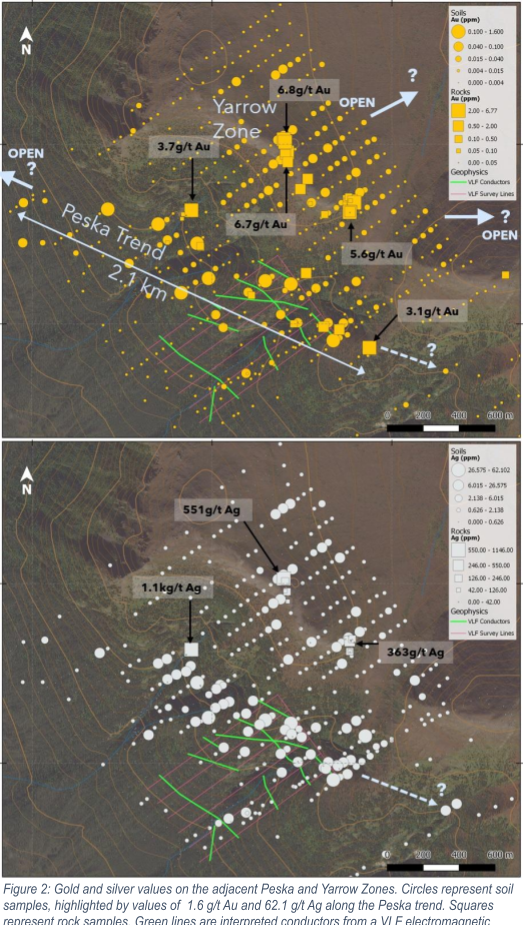
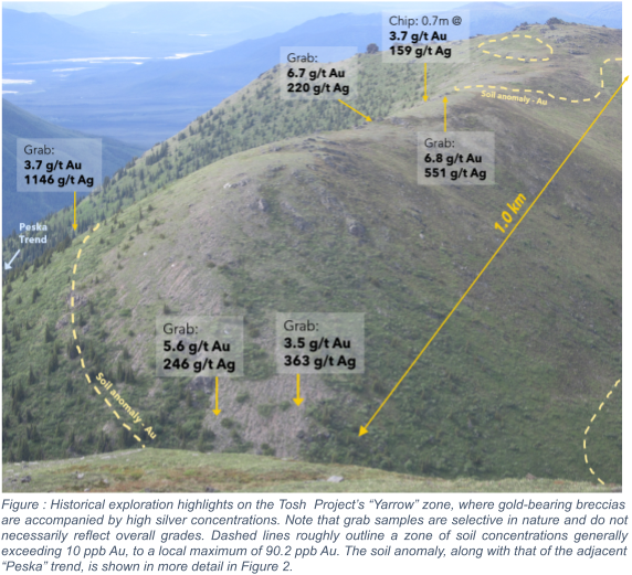
- Mineralized rock samples up to 6.8 g/t gold and up to 1,146 g/t silver over a 15 kilometre area
- Multiple open-ended soil anomalies at least 2.1 kilometres in length with highlight soil concentrations of 5.8 g/t gold and 62.1 g/t silver
Vancouver, B.C., March 23, 2021 SNOWLINE GOLD CORP. (CSE: SGD) (the “Company” or “Snowline”) is pleased to provide additional information on its 100% owned, 1,630-hectare Tosh Gold Project (the “Tosh Project”). Precious metal mineralization at the Tosh Project is found along kilometre-scale shear zones, in quartz-carbonate veins, breccias and silicified shales, with assay results up to 6.8 g/t Au and 1,146 g/t Ag in rock grab samples over an area spanning 15 kilometres.
“The Tosh Project speaks to the depth of Snowline’s exploration portfolio,” said Scott Berdahl, Snowline’s COO. “Widespread prospecting discoveries accompanied by kilometres-scale, multi-element soil anomalies in a geological and structural setting similar to White Gold’s camp attests to the Tosh Project’s scale and potential. The encouraging historical results justify advanced exploration.”
Snowline is reviewing its newly acquired project portfolio and is focused on planning and prioritizing its exploration to maximize shareholder value. Specifically, it is examining multiple options for its non-core assets, including targeted exploration and joint venture arrangements.
The Tosh Project bears many hallmarks of a significant orogenic gold camp. Host rocks are high-strain schists and intercalated marbles of the Yukon Tanana terrane, the geologic province that hosts two recently discovered million-ounce-plus gold deposits (including Newmont’s “Coffee” deposit, ~115 km to the north of the Tosh Project) and from which over 12.5 million ounces of placer gold has been recovered in the Klondike goldfields. Importantly, major regional faults cut Cretaceous and Paleogene intrusive rocks in the vicinity of the Tosh Project.
Grid soil sampling (1,379 samples) at the Tosh Project revealed two prominent NW-SE trending zones of anomalous (defined by 90th percentile gold values >27 ppb Au) multi-element geochemistry, “Peska” and “Koose,” separated by 12 kilometres of prospective ground. Gold in soil values assay up to 5.8 g/t Au at Koose and 1.6 g/t Au at Peska. These zones extend roughly 2 kilometres each and remain open in both directions on trend. A historical ground-based VLF electromagnetic geophysical survey over part of the Peska zone suggests the presence of continuous conductive structures. These structures may correspond to an anomaly that spans at least 500 metres, extending along trend off both edges of the survey. Out of 66 rock samples at Peska and Yarrow, 14 assayed higher than 1.0 g/t Au and 9 above 100 g/t Ag. Additional prospective areas at Tosh have yet to be thoroughly explored.
The Tosh Project is located 20 kilometres from the paved, all-season Alaska Highway. Follow up exploration at the Tosh Project will focus on delineating high priority drill targets.