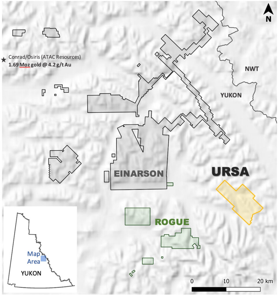
- Project Size: 7,755 hectares
- Black shale hosted gold and silver & base metals
- Potential for very large mineralized systems
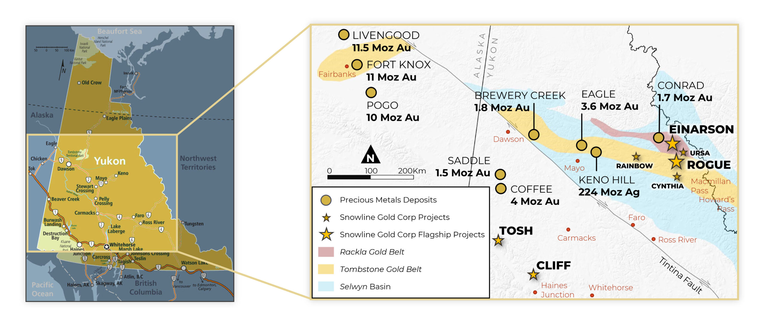
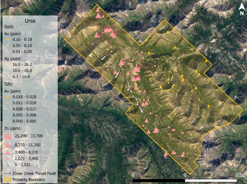
Ursa covers two distinct geochemical trends: a 9 km trend of elevated to anomalous gold in stream sediment and soil samples, and a roughly parallel 14 km trend of elevated to highly anomalous zinc accompanied by elevated silver, copper, molybdenum, nickel and vanadium. The Selwyn Basin is home to world-class base metal districts such as Howard’s Pass (423 Mt @ 4.8% Zn, 1.6% Pb1) and the Anvil district (120 Mt @ 5.6% Zn, 3.7% Pb, 45 g/t Ag2), both in similar stratigraphy to that of Ursa, and it is an important host to several types of gold deposit.
Gold Target
The east side of the Ursa property covers a 9-kilometer trend of elevated gold in stream sediments and soils in a sequence of heavily folded carbonaceous black shales and cherts. Gold was discovered in black shale hosted pyrite nodules by a previous operator searching for Carlin-style targets. No major carbonate units were encountered, but subsequent analysis of field data by Snowline’s technical team determined that Ursa’s geological setting is similar to Russia’s Sukhoi Log deposit (67 Moz Au at 1.9 g/t3), in which gold is hosted in pyritic nodules and masses. The carbonaceous, passive margin shales in both areas have been compressed into a tight anticlinorium and later intruded in their vicinities by felsic plutons. At Ursa, these plutons are members of the Tombstone plutonic suite that drive the intrusion-related gold targets at Rogue. There has been very little, if any, previous exploration for this deposit type in the Selwyn Basin.
Base Metal Target
The west side of the Ursa property covers a 14-kilometer trend of elevated to highly anomalous zinc, silver, copper, molybdenum, nickel and vanadium thought to be associated with Devonian age enriched black shales. Of 45 historic stream sediment samples draining the length of the trend, 44 returned concentrations exceeding 0.1% Zn, with 8 of these samples exceeding 1% Zn to a maximum of 3.4% Zn. Concentrations of up to 0.48% Ni, up to 0.18% Cu and up to 118.5 ppm Mo were also returned by this stream sediment sampling along the trend. Historic, first-pass contour soil sampling along a subsection of the trend revealed a zone 500 m to 1,500 m wide along the length of the 6.7-kilometer subsection wherein soils consistently exceed 5 g/t Ag. A 2.7 kilometer-long, 43-sample contour soil line within this subsection had a median concentration of 14.8 g/t (0.43 oz/ton) silver.
2021 Exploration
Ursa’s proximity to Snowline’s flagship Rogue and Einarson projects allows for efficient exploration during the 2021 field season. Geochemical sampling, prospecting and mapping are planned to better understand the sources of the gold and base metal anomalies. Based on these results, geophysical surveying, surface trenching and initial drill testing may be conducted later in the season.
References
- Source: Yukon Minfile 105I 068, combined indicated and inferred global resource.
- Source: Porter Geoscience Database Faro – Anvil, Vangorda, Grum, DY, Swim, combined global resource based on figures from relevant Yukon Minfiles.
- Source: Polyus website, measured, indicated and inferred resources for Sukhoi Log.