Rogue Project
Anchored by the Valley gold deposit, Snowline’s flagship Rogue Project covers a 60 x 30 km cluster of gold-bearing intrusions in the eastern Tombstone Gold Belt
Valley PEA: Potential for a Robust, High Margin Operation2
Valley PEA - By The Numbers
544
koz/year
341 koz/year life-of-mine
US $569
oz/year
US $844/oz life-of-mine
6.8
Moz
From 7.4 Moz @ 1.34 g/t Au
20
years
$1.7B CDN
1.09:1
$3.4B CDN
25%
Valley Mineral Resource
1 The PEA is preliminary in nature and includes Inferred Mineral Resources that are considered too speculative geologically to have economic considerations applied to them that would enable classification as Mineral Reserves. There is no certainty that the results of the PEA will be realized. 2 The PEA is detailed in the recent technical report for Rogue, prepared in accordance with NI 43-101 standards, entitled “Independent Preliminary Economic Assessment for the Rogue Project Yukon, Canada,” dated August 27, 2025, with an effective date of March 1, 2025, available on SEDAR+ and the Company’s website. 3 All-in Sustaining Costs (AISC) are a non-GAAP measure; the sum of site operating costs, product transportation and selling costs, royalty payments, sustaining capital and progressive reclamation costs, divided by payable gold ounces produced. AISC excludes closure costs and any post-closure costs. 4 After-tax NPV and IRR are calculated as of the assumed start of construction (Period -4), use a CAD/USD exchange rate of 1.40, and the gold price (US$/oz) indicated
Mineral Resource table notes are available here.
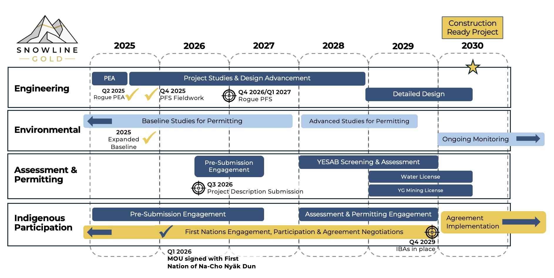
Conceptual Advancement Timeline

Snowline Gold’s 100%-owned, flagship Rogue Project, in Canada’s Yukon Territory, covers a 60 x 30 km cluster of intrusions in the eastern Tombstone Gold Belt known as the Rogue Plutonic Complex.
Since its launch in 2021, Snowline has advanced the Rogue Project’s Valley deposit from a greenfield prospecting discovery to a significant bulk tonnage gold resource, with a combined 7.94 Moz gold Measured and Indicated mineral resource at 1.21 g/t Au and an additional 0.89 Moz Inferred mineral resource at 0.62 g/t Au within a pit-shell constraint. A Preliminary Economic Assessment completed in 2025 highlights robust economics across a wide range of gold price environments.
Exploration of the open Valley deposit is ongoing. Valley is a reduced intrusion-related gold system (RIRGS), geologically similar to multi-million-ounce RIRGS deposits currently in production, like Kinross’s bulk-tonnage Fort Knox Mine in Alaska, but with substantially higher gold grades. Gold is associated with bismuthinite and telluride minerals hosted in sheeted quartz vein arrays within and along the margins of a one-kilometer-scale, mid-Cretaceous aged Mayo-series intrusion.
The Rogue Project hosts multiple intrusions geologically similar to Valley and associated with widespread gold anomalism in stream sediment, soil and rock samples. Elsewhere, RIRGS deposits are known to occur in clusters. For these reasons, Snowline considers the Rogue Project to have district-scale potential to host additional reduced intrusion-related gold systems.
